Image copyright, John Tallet, 2003.  Click to return to the Homepage.
USK WALKS
Welsh flag
HOMEPAGE
ABOUT USINDEX OF WALKSLOCAL LINKSMAPS MISCELLANEOUS
WALK 1 WALK 2WALK 3WALK 4WALK 5WALK 6WALK 7WALK 8WALK 9WALK 10 WALK 11
WALK 12
WALK 13 WALK 14 WALK 15 WALK 16 WALK 17 WALK 18 WALK 19 WALK 20 WALK 21

Walk No 5: Gwehelog - Llancayo
(6 miles - about 1¾ hours; directions last checked (not revised) on 13.11.23)


This is a moderate walk on quiet country lanes, including a few steep hills, taking in some of the beautiful countryside north of Usk. There are no toilets on the route, except in Usk itself and at the Hall Inn in Gwehelog.


Between Usk and Gwehelog

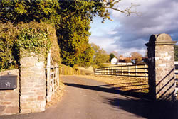
Leave the town square and turn right on the main road in the direction of Raglan and the A449. After passing the school, take the minor road to Gwehelog (straight on) where the main road bends right.

Continue straight on at the junction with Ladyhill. After ¼ mile turn right into a lane by the allotments. This lane passes a number of farms.

Follow this for nearly 2 miles, finally climbing the short steep hill to the village of 
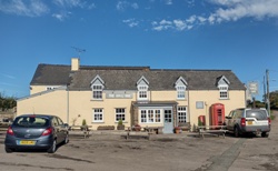
Gwehelog.

At the top of the hill go straight on and cross the main road to take the lane to the right of the village hall (a green metal building). (NB: A hundred yards up the main road from this point is the Hall Inn where a good selection of meals can be had.)


The Hall Inn, Gwehelog

North of Llancayo
North of Llancayo
(See enlargement)


After 4 minutes bear left at the first fork, where there is a Neighbourhood Watch sign. Go straight on at the next crossroads, where there is a house called "Ty Mynydd". After 4 minutes, at a crossroads, where a bridleway is straight ahead, turn left on a lane (not signposted to anywhere).

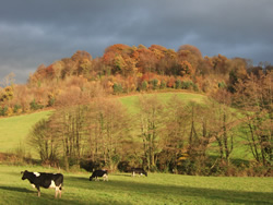
Follow the lane downhill and then through an attractive wooded valley. Pass Upper Llancayo Farm and turn left on the main road to Usk. Watch out for traffic as there is no pavement for the next 5 minutes.
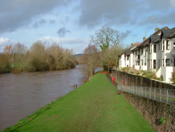
 

Walk parallel to the river, back into the town centre, turn left at the T-junction and return to the town square.

(A short optional detour is to take the path through the kissing gate just before the veterinary practice and walk along the riverbank ("Conigar Walk") as far as the bridge. Take the path up to the road and turn left.)
(See a photo of a commemorative plaque giving the history of the bridge and another explaining the origin of "Conigar Walk".)


River Usk photographed from the road bridge

River Usk and Conigar Walk

See route on Google Maps

A laminated A5 card showing this walk route, along with photographs, can be easily ordered here.
The walk can be ordered more cheaply in digital format (PDF file) on the alternative Order Form.

return to top >>>

WALK 1 WALK 2WALK 3WALK 4WALK 5WALK 6WALK 7WALK 8WALK 9WALK 10 WALK 11
WALK 12
WALK 13 WALK 14 WALK 15 WALK 16 WALK 17 WALK 18 WALK 19 WALK 20 WALK 21

Page last updated 14.11.23